About the neighborhood
Historic district of San Juan, Puerto Rico
Old San Juan (Spanish: Viejo San Juan) is a historic district or quarter located at the "northwest triangle" of San Juan Islet in San Juan, Puerto Rico. Its area roughly correlates to the Ballajá, Catedral, Marina, Mercado, San Cristóbal, and San Francisco sub-barrios (sub-districts) of barrio San Juan Antiguo in the municipality of San Juan, Puerto Rico.
Old San Juan is the oldest settlement within Puerto Rico and the historic colonial district of the city of San Juan. This historic district is a Puerto Rico Registered Historic Zone and a National Historic Landmark District, Old San Juan Historic District, and is also listed on the United States National Register of Historic Places. Several historical buildings and structures, particularly La Fortaleza, the city walls, and El Morro and San Cristóbal castles, have been inscribed in the UNESCO World Heritage Site list since 1983.
Historically the mixed-use commercial and residential real estate in the main streets of Calle Cristo and Calle Fortaleza from Calle Tanca to the Governor's Mansion is the most valuable in the area and it has kept its value and increased steadily through several years despite the past economic turmoil.
Location
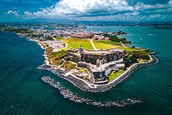
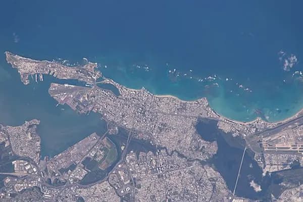
Old San Juan is located on a small and narrow island which lies along the north coast, about 56 kilometres (35mi) from the east end of Puerto Rico, and is connected to the mainland of Puerto Rico by three bridges. It is bounded by the Atlantic Ocean to the north and to the south by San Juan Bay (Bahia de San Juan)—which lies between the city and the mainland. On a promontory (morro) about 30 metres (100ft) high, at the west end of the island and commanding the entrance to the harbor, rise the battlements of Fort San Felipe del Morro, and its lighthouse.
The San Antonio Channel (Caño de San Antonio) lies to the southeast, where the island of Old San Juan connects to the mainland through Santurce, by three bridges: Dos Hermanos (Ashford Avenue), G. Esteves (Ponce de León Avenue) and San Antonio (Fernández Juncos Avenue).
The city is characterized by its narrow, blue cobblestone streets, and flat-roofed brick and stone buildings, which date back to the 16th and 17th centuries—when Puerto Rico was a Spanish possession. Near Fort San Felipe del Morro, is the Casa Blanca, a palace built on land which belonged to the family of Ponce de León.
History
Origins
In 1508, Juan Ponce de León founded the original settlement, Caparra (named after the Province of Cáceres, Spain, birthplace of the then-governor of Spain's Caribbean territories, Nicolás de Ovando). The ruins of Caparra are known as the Pueblo Viejo sector of Guaynabo, behind the almost land-locked harbor just to the west of the present San Juan metropolitan area. In 1509, the settlement was abandoned and moved to a site which was called at the time "Puerto Rico" (meaning "rich port" or "good port"), a name that evoked that of a similar geographical harbor in the island of Gran Canaria, Canary Islands. The official settlement of this new town was marked by the establishment of the Roman Catholic Archdiocese of San Juan in 1511, the first Catholic diocese to be established in the Americas, and by the construction of the first wooden iteration of its cathedral in 1513 together with the establishment of a Latin school by bishop Alonso Manso.
In 1521, this new settlement was given its formal name of "Ciudad de Puerto Rico de San Juan Bautista", following the custom of christening the primary settlement of an island colony with both its formal town name and the name given by Christopher Columbus to the island, honoring John the Baptist. The settlement was also platted this same year, with many of its first streets and plazas being built at the time, such Calle del Cristo, Plaza de Armas and Plaza de la Catedral. Also constructed in 1521, Casa Blanca served as the first fortification of the settlement and residence of Juan Ponce de León and his descendants until the mid-eighteenth century.
Expansion and growth
Some of the first European establishment in the Western Hemisphere were also established in Old San Juan during the mid and second half of the16th century. Some of these include the Thomas Aquinas Convent (today the National Gallery of Puerto Rico) in 1523, Nuestra Señora de la Concepción Hospital in 1524, and the former Gothic stone cathedral building.
The strategic position of Old San Juan in the context of the Caribbean and the Atlantic Ocean also made it a target for foreign attacks, which motivated the erection of a city wall between 1530 and 1560. Several fortresses and castles were also build during this time: La Fortaleza was built between 1533 and 1540, followed by the construction of the first battery at El Morro. Plans for the castle portion of San Felipe del Morro were made in 1584. Extensions, plus construction of El Cañuelo and El Boquerón forts, were made between 1599 and 1609. Complete circumvallation of the city was finally completed in 1641. Although several fortresses were built at the site during the time, it was not until 1771 when San Cristobal, the largest of the fortresses, was completed.
By 1776, the population totaled 6000, half of which were soldiers. The garrison town of San Juan included 100 hectares (250 acres) of military installations and 25 hectares (62 acres) of public and private use. By 1781, the city's fortifications included 376 cannon. By 1876, 24,000 lived inside the walls of San Juan, encompassing 25 hectares, and 926 buildings.
Prior to the 19th century, the area outside the city walls occupying the east side of Old San Juan Island, was almost uninhabited. In 1838 the so-called area of Puerta de Tierra had a population of 168 residents, mainly of African descent. According to a census made in 1846, the population had risen to 223 inhabitants living in 58 houses. On March 3, 1865, the municipal government of San Juan approved a resolution promoting the city expansion across the Puerta de Tierra which included the plan for demolishing the city walls along the eastern side. On May 28, 1897, the wall demolition was officially started after a proclamation was issued by Queen Maria Christina. By the year 1899, the population of Puerta de Tierra had risen to 5,453; while the area comprising the old walled city had a civilian population of roughly 18,103 inhabitants.
Maintaining architectural integrity
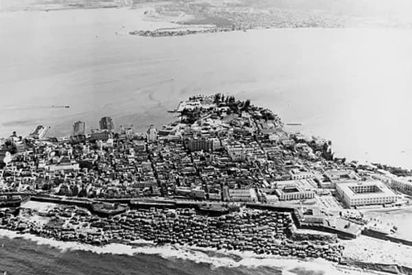
During the late 1940s, disrepair in the old city was evident. The local authorities were considering development proposals for renovating the old city and incorporating modern architecture on new constructions. Anthropologist Ricardo Alegría vehemently advised against the idea of demolishing old colonial buildings in favor of contemporary building designs. He followed the example suggested by his father, a local civic leader who had successfully prevented the demolition of the Capilla del Cristo in favor of a traffic redesign. He advised mayor Rincón de Gautier in having local zoning laws changed to favor remodeling and the incorporation of Spanish colonial motifs in any new construction. This helped preserve the city's architectural profile, and has been a key to San Juan's current status as a tourist destination.
Luis Muñoz Marín, as a senator and later as governor of Puerto Rico, supported and implemented what became known as Operation Bootstrap, which included the development of the tourism industry. In 1948 the government invited one of the organizers of Colonial Williamsburg to lead its tourism development efforts. These efforts were further supported by the 1955 creation of the Institute of Puerto Rican Culture (Instituto de Cultura Puertorriqueña) head by Alegría. He sought legal and administrative changes that would allow for major remodeling efforts to be successful. At the time, most real estate in Old San Juan had devalued under appraised values because the city was perceived as unsafe (particularly because of building disrepair and social ills such as prostitution) and not profitable for business (because of rent control statutes, as well as the reluctance of commercial banks to fund remodeling). Under combined efforts by the institute and the Government Development Bank for Puerto Rico, "model" remodelings were made to show potential property owners how their renewed properties could look. Strict remodeling codes were implemented to prevent new constructions from affecting the common colonial Spanish architectural themes of the old city. As with other Operation Bootstrap projects, mainland corporate investors were lured in with tax breaks and other incentives. When a project proposal suggested that the old Carmelite Convent in San Juan be demolished to erect a new hotel, the Institute had the building declared a historic building, and asked that it be converted to a hotel in a renewed facility. As in other Operation Bootstrap projects, the Woolworth family was invited in 1957 to reconstruct the former convent (which had more recently been a low-rent apartment building and city garage) into the luxury Hotel El Convento. The Bank provided low interest loans to remodelers, and the government gave triple tax exemptions to commercial activities in the old city (they were exempted for a limited time, not only from property taxes and municipal taxes, but from income tax from activities generated in their properties as well). At least one retailer from the shopping district in Charlotte Amalie was given incentives to set up shop in the Calle del Cristo (the city's red light district during the early 1940s) in order to persuade other retailers to follow suit and somehow "clean up" the district. Potential developers were offered sketches of their properties after a remodeling, as to suggest which architectural elements to improve or change. The paradigm to reconstruct and renovate the old city and revitalize it has been followed by other cities in Latin America, particularly Havana, Lima and Cartagena de Indias.
Historic designations
The San Juan National Historic Site (Spanish: Sitio Histórico Nacional de San Juan) was established in 1949 to preserve historic fortifications in Old San Juan and the National Register of Historic Places listed it in 1966. Both that site and La Fortaleza (English: The Fortress) were then declared a single World Heritage Site by UNESCO in 1983.
In 1951, the broader area within the old city walls became the first listing of the Puerto Rico Register of Historic Sites and Zones as the Zona Antigua Histórica Casco de San Juan (English: Historic Old Town Area of San Juan). In 1972, the same area was recognized by the National Register of Historic Places as the San Juan Historic Zone (Spanish: Zona Histórica de San Juan). In 2012, the National Register increased the boundaries and renamed the district to Old San Juan Historic District (Spanish: Distrito Histórico del Viejo San Juan). Old San Juan was then designated a National Historic Landmark District in 2013.
Landmarks and attractions
La Fortaleza and the San Juan National Historic Site
San Cristóbal Castle (Castillo San Cristóbal), the largest fortification built by the Spanish in the Americas, which provided defense against both land-based and sea attacks by pirates and foreign powers during the colonial period.
San Felipe del Morro Castle (Castillo San Felipe del Morro, or just El Morro), a 16th century citadel in the northwestern edge of the islet that provided defense against foreign and pirate attacks during the Spanish colonization, also the site of a historic lighthouse.
Santa Catalina Palace, popularly known as La Fortaleza (Spanish for the fortress), a former fortification and currently the official residence of the governor of Puerto Rico. It is the oldest executive residence in the Western Hemisphere.
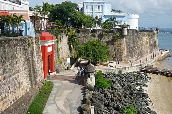
The San Juan City Walls surround Old San Juan and it gives the city one of its nicknames, "La ciudad amurallada" (the walled city). About 3/4 of the city walls remain intact but only one of the city gates remain in existence. San Juan is one of the six cities under United States jurisdiction that possessed defensive walls and it is the only US city that still preserves its colonial defensive wall system.
Plazas and squares
Paseo de La Princesa (Spanish for promenade of the princess) is a famous promenade named after the former La Princesa Prison. It extends for 400 metres (1,300ft) and runs along the southern city wall of Old San Juan. It provides views of San Juan's city walls and San Juan Bay, and it is a popular location that becomes very lively during festivals and other cultural celebrations. A boardwalk at the end of the promenade connects it to Puerta de San Juan (the San Juan City Gate), formerly known as Puerta de Agua (Spanish for water gate), the only remaining city gate.
Plaza Colón (Spanish for Columbus square or plaza) is located in the eastern end of Old San Juan where the former eastern city walls used to be located. Originally named Santiago Square, the plaza is now a popular meeting place for locals and tourists as it is located next to famous landmarks such as the San Cristóbal castle and the Tapia Theater.
Plaza de Armas is the main town square of San Juan where several administrative buildings such as the historic San Juan City Hall are located. A plaza de armas is a large square often found in Spanish-founded cities across the Americas and the Philippines that were originally intended for military parades, hence the name "plaza de armas" (literally arms or weapons square).
Plaza de la Catedral (English: Cathedral Square), popularly known as Plazuela Las Monjas, is located south of Hotel El Convento and west of the main entrance to San Juan's cathedral.
Plaza de San José (English: San José Square), formerly known as Plaza de Santo Domingo, is located next to San José Church. It is also a popular meeting place due to its location next to restaurants and other businesses important to Old San Juan's nightlife. The statue of Ponce de León located in the center of the square is famous for being built from melted British cannons obtained after Sir Ralph Abercromby's failed attempt to capture San Juan.
Plaza del Quinto Centenario (English: Square of the Fifth Centenary) is a modern square built to commemorate the 500th year anniversary of San Juan and the European discovery of Puerto Rico and the Americas. The square is located next to the Ballajá Barracks and El Morro.
Plazuela de la Rogativa is a small plaza located close to La Fortaleza that is famous for the bronze sculpture of La Rogativa. The sculpture, completed by New Zealand artist Lindsay Daen in 1971, portrays "La Rogativa" (Spanish for the pleading), from a legend that says that the British invasion led by Sir Abercromby was foiled thanks to a pleading procession led by the bishop of San Juan and a group of women carrying torches. The story states that the British mistook the procession for Spanish reinforcements.
Encyclopedic content adapted from the Wikipedia article on Old San Juan, used under CC BY-SA 4.0.