About the neighborhood
Provincial capital of Quebec, Canada
Quebec City (French: Ville de Québec) is the capital city of the Canadian province of Quebec. As of July 2021, the city had a population of 549,459, and the Census Metropolitan Area (including surrounding communities) had a population of 839,311. It is the twelfth-largest city and the seventh-largest metropolitan area in Canada. It is also the second-largest city in the province, after Montreal. It has a humid continental climate with warm summers coupled with cold and snowy winters.
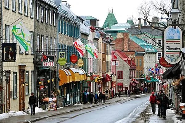
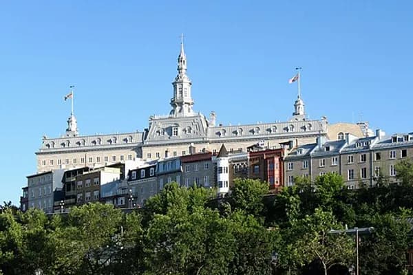
Explorer Samuel de Champlain founded a French settlement here in 1608, and adopted the Algonquin name. Quebec City is one of the oldest European settlements in North America. The ramparts surrounding Old Quebec (Vieux-Québec) are the only fortified city walls remaining in the Americas north of Mexico. This area was declared a World Heritage Site by UNESCO in 1985 as the "Historic District of Old Québec".
Name and usage
Common English-language usage distinguishes the city from the province by referring to the former as Quebec City.
According to the Government of Canada, the Government of Quebec, and the Geographical Names Board of Canada, the names of Canadian cities and towns have only one official form. Thus, Québec is officially spelled with an accented é in both French and Canadian English. However, province names can have different forms in English and French. As a result, in English, the federal government style distinguishes the city and province by spelling the city with an acute accent (Québec) and the province without one (Quebec). The government of Quebec spells both names "Québec", including when writing in English.
In French, the two are distinguished in that province names including Quebec generally take definite articles, while city names do not. As a result, the city is Québec and the province is le Québec; "in Quebec City" is à Québec and "in the province of Quebec" is au Québec; and so forth.
The Algonquian people had originally named the area Kébec, an Algonquin language word meaning "where the river narrows", because the Saint Lawrence River narrows by the promontory of Quebec and its Cape Diamant.
History
French regime (1500s–1763)
Quebec City is one of the oldest European settlements in North America and the only fortified city north of Mexico whose walls still exist. While many of the major cities in Latin America date from the 16th century, among cities in Canada and the United States, few were created earlier than Quebec City (St. John's, Harbour Grace, Port Royal, St. Augustine, Santa Fe, Jamestown, and Tadoussac).
It is home to the earliest known French settlement in North America, Fort Charlesbourg-Royal, established in 1541 by explorer Jacques Cartier with some 400 persons but abandoned less than a year later due to the harsh winter and resistance of indigenous inhabitants to colonial incursion on their land. The fort was at the mouth of the Rivière du Cap Rouge, in the suburban former town of Cap-Rouge (which merged into Quebec City in 2002).
Quebec was founded by Samuel de Champlain, a French explorer and diplomat, on 3 July 1608, and at the site of a long abandoned St. Lawrence Iroquoian settlement called Stadacona. Champlain, who came to be called "The Father of New France", served as its administrator for the rest of his life.
The name "Canada" was given to the colony that developed around the settlement at Quebec. Although the Acadian settlement at Port-Royal was established three years earlier, Quebec came to be known as the cradle of North America's Francophone population. The location seemed favourable to the establishment of a permanent colony.
The population of the settlement remained small for decades. In 1629 it was captured by English privateers, led by David Kirke, during the Anglo-French War. Samuel de Champlain argued that the English seizing of French lands was illegal as the war had already ended, and worked to have them returned to France. As part of the ongoing negotiations following the end of the Anglo-French War, in 1632 the English king Charles I agreed to return captured lands in exchange for Louis XIII paying his wife's dowry. These terms were signed into law with the Treaty of Saint-Germain-en-Laye. The colonies of Canada and Acadia were returned to the French Company of One Hundred Associates.
In 1665, there were 550 people in 70 houses living in the city. One-quarter of the people were members of religious orders: secular priests, Jesuits, Ursulines nuns and the order running the local hospital, Hôtel-Dieu.
Quebec was the headquarters of many raids against New England during the French and Indian Wars. In 1690 the city was attacked by the English, but was successfully defended. In the last of the conflicts, the French and Indian War (Seven Years' War), Quebec was captured by the British in 1759, and held until the end of the war in 1763. In that time many battles and sieges took place: the Battle of Beauport, a French victory (31 July 1759); the Battle of the Plains of Abraham, in which British troops under General James Wolfe defeated the French General Louis-Joseph de Montcalm on 13 September 1759, and shortly thereafter took the city after a short siege. A French counterattack saw a French victory at the Battle of Sainte-Foy (28 April 1760) but the subsequent second Siege of Quebec the following month however saw a final British victory.
France ceded New France, including the city, to Britain in 1763, when the French and Indian War officially ended.
At the end of French rule, Quebec was a town of 8,000 inhabitants, surrounded by forests, villages, fields and pastures. The town was distinguished by its monumental architecture, fortifications, and affluent homes of masonry and shacks in the suburbs of Saint-Jean and Saint-Roch. Despite its urbanity and its status as capital, Quebec remained a small city with close ties to its rural surroundings. Nearby inhabitants traded their farm surpluses and firewood for imported goods from France at the two city markets.
British and Canadian rule (1763–present)
During the American Revolution, revolutionary troops from the southern colonies assaulted the British garrison in the city in the hope that the peoples of Quebec would rise and join the American Revolution so that Canada would join the Continental Congress, along with the other British colonies of continental North America. The American invasion failed, however, and the war resulted in a permanent split of British North America into two entitles: the newly independent United States of America, and those colonies (including Quebec) that remained under British control, which would later become the country of Canada.
The city itself was not attacked during the War of 1812, when the United States again attempted to annex Canadian lands. Amid fears of another American attack on Quebec City, construction of the Citadelle of Quebec began in 1820. The Americans did not attack Canada after the War of 1812, but the Citadelle continued to house a large British garrison until 1871. It is still in use by the military and is also a tourist attraction.
Until the late 18th century Québec was the most populous city in present-day Canada. As of the census of 1790, Montreal surpassed it with 18,000 inhabitants, but Quebec, which had about 14,000 of population at that time, remained the administrative capital of the former New France. It was then made the capital of Lower Canada by the Constitutional Act of 1791. From 1841 to 1867, the capital of the Province of Canada rotated between Kingston, Montreal, Toronto, Ottawa and Quebec City (from 1851 to 1855 and from 1859 to 1865).
The city experienced an economic golden age in the 1800s, due to its favorable location on the Saint Lawrence River which gave rise to industries of wooden sailing ships manufacture, export of squared timber logs. to Europe, as well as associated enterprises such as sawmills. However, by the 1870s, Québec City entered a period of economic decline. Contributing factors included the rise of steel-hulled steamships, the expansion of railroads at the expense of waterways for continental commerce; the depletion of forest resources near major rivers upstream of Québec City and in the west of the province, which were transported to Québec's port by log driving; the construction of locks on the Saint Lawrence Seaway, opening up trade routes to the U.S. from Montreal; and the city's inability to retain immigrant populations. This unfavourable context, coupled with the departure of the British army from the city's Citadel in 1871, contributed to the exodus of English speaking populations, such as local bourgeoisie of Scottish origin or workers of Irish background, to Montreal in the second half of the 19th century. Anglophones made up approximately 40% of the city's population in 1861, but 16% in 1901.
Before the Royal Military College of Canada was established in 1876, the only French-speaking officer training school was the Quebec City School of Military Instruction, founded in 1864. The school was retained at Confederation, in 1867. In 1868, The School of Artillery was formed in Montreal.
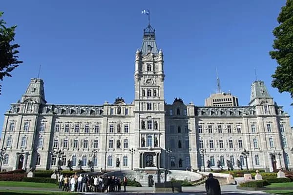
The Quebec Conference on Canadian Confederation was held in the city in 1864. In 1867, Queen Victoria chose Ottawa as the definite capital of the Dominion of Canada, while Quebec City was confirmed as the capital of the newly created province of Quebec.
During World War II, two conferences were held in Quebec City. The First Quebec Conference was held in 1943 with Franklin D. Roosevelt (President of the United States), Winston Churchill (Prime Minister of the United Kingdom), William Lyon Mackenzie King (Prime Minister of Canada) and T. V. Soong (minister of foreign affairs of China). The Second Quebec Conference was held in 1944 and was attended by Churchill and Roosevelt. They took place in the buildings of the Citadelle and at the nearby Château Frontenac. A large part of the D-Day landing plans were made during those meetings.
Until 2002, Quebec was a mostly urbanized city and its territory coterminous with today's borough of La Cité-Limoilou. The Government of Quebec then mandated a municipal reorganization in the province, and many suburbs of the north shore of the Saint-Lawrence were merged into Quebec City, taking the form of boroughs, thus constituting the boundary of present-day Québec City. In 2008 the city celebrated its 400th anniversary and was gifted funds for festivities and construction projects by provincial and federal governments, as well as public artwork by various entities, including foreign countries.
Geography
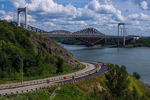
Quebec City was built on the north bank of the Saint Lawrence River, where it narrows and meets the mouth of the Saint-Charles River. Old Quebec is located on top and at the foot of Cap-Diamant, which is on the eastern edge of a plateau called the promontory of Quebec (Quebec hill). Because of this topographic feature, the oldest and most urbanized borough of La Cité-Limoilou can be divided into upper and lower town. North of the hill, the Saint Lawrence Lowlands is flat and has rich, arable soil. Past this valley, the Laurentian Mountains lie to the north of the city but its foothills are within the municipal limits.
The Plains of Abraham are located on the southeastern extremity of the plateau, where high stone walls were integrated during colonial days. On the northern foot of the promontory, the lower town neighbourhoods of Saint-Roch and Saint-Sauveur, traditionally working class, are separated from uptown's Saint-Jean-Baptiste and Saint-Sacrementfr by a woody area attested as Coteau Sainte-Genevièvefr.
The area was affected by the 1925 Charlevoix–Kamouraska earthquake.
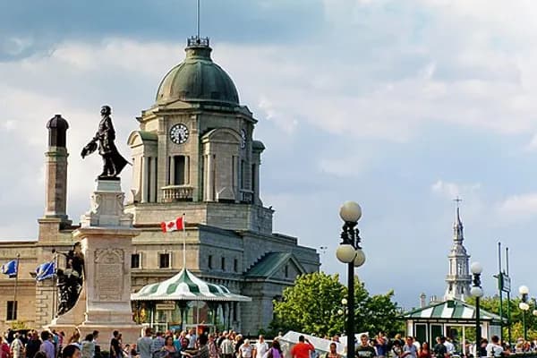
The administrative region in which it is situated is officially referred to as Capitale-Nationale, and the term "national capital" is used to refer to Quebec City itself at the provincial level.
Climate
Quebec City is classified as a hemiboreal humid continental climate (Köppen climate classification Dfb, Trewartha Dcbc).
Quebec City experiences four distinct seasons. Summers are warm and occasionally hot, with periods of hotter temperatures which compounded with the high humidity, create a high heat index that belies the average high of 22–25°C (72–77°F) and lows of 11–13°C (52–55°F). Winters are cold, windy and snowy with average high temperatures −5 to −8°C (23 to 18°F) and lows −13 to −18°C (9 to 0°F). Spring and fall, although short, bring chilly to warm temperatures. Late heat waves as well as "Indian summers" are a common occurrence.
On average, Quebec City receives 1,190 millimetres (46.85in) of precipitation, of which 899 millimetres (35.39in) is rain and 303 millimetres (11.93in) is the melt from 316 centimetres (124.4in) of snowfall per annum. The city experiences around 1,916 hours of bright sunshine annually or 41.5% of possible sunshine, with summer being the sunniest, but also slightly the wettest season. During winter, snow generally stays on the ground from the end of November till mid-April.
The coldest temperature ever recorded was −36.7°C (−34.1°F) on 10 January 1890 and 14 January 2015. The highest temperature ever recorded in Quebec City was 36.1°C (97.0°F) on 17 July 1953., with the current weather station at the airport having a record of 35.6°C (96.1°F) the same day. The record highest daily minimum was 23.2°C (73.8°F) recorded 10 July 1955. The record highest dew point was 28.2°C (82.8°F) recorded 2 July 2002. The most humid month was July 2023 with an average dew point of 17.7°C (63.9°F). The warmest month was July 2010 with a recorded average mean temperature of 21.6°C (70.9°F). July 1959 recorded the warmest monthly average daily maximum of 28.7°C (83.7°F). July 2023 recorded the warmest monthly average daily minimum of 16.0°C (60.8°F). July 2019 saw no daily maximum temperature below 22.1°C (71.8°F) during the entire month. July 2020 recorded no temperature below 11.0°C (51.8°F) throughout the month. The month of August 2015 recorded no dew point below 10.3°C (50.5°F).
The lowest yearly maximum dew point is 20.0°C (68.0°F) recorded in 1960. The lowest yearly maximum daily minimum temperature is 16.7°C (62.1°F) recorded in 1956 and 1962. The lowest yearly maximum temperature is 28.9°C (84.0°F) recorded in 1954 and 1958.
The average yearly maximum dew point is 23.1°C (73.6°F) and the average yearly maximum daily minimum temperature is 20.3°C (68.5°F).
Boroughs and neighbourhoods
Encyclopedic content adapted from the Wikipedia article on Saint-Jean-Baptiste, used under CC BY-SA 4.0.