About the neighborhood
Municipality in Vietnam
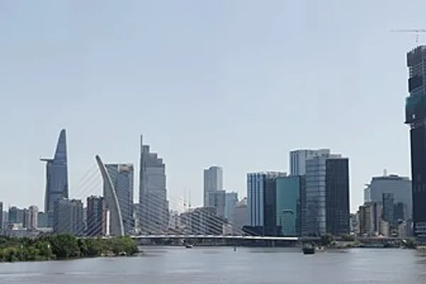
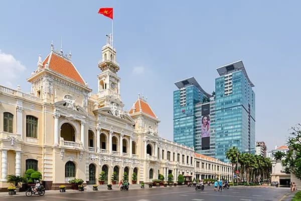
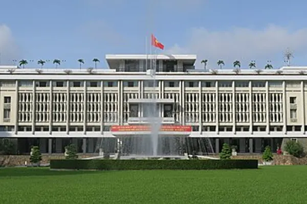
Ho Chi Minh City (HCMC; Vietnamese: Thành phố Hồ Chí Minh, IPA: tʰaɲ˨˩ fow˦˥ ho˨˩ cɪj˦˥ mɨn˧˧ ), also known as Saigon, is the most populous municipality of Vietnam, with a population of more than 14 million in 2025. Its geography is defined by rivers and canals, of which the largest is Saigon River. As the largest financial centre in Vietnam, Ho Chi Minh City has the largest gross regional domestic product out of all Vietnam provinces and municipalities, contributing around a quarter of the country's total GDP. It is the busiest international transport hub in Vietnam, with Tân Sơn Nhất International Airport accounting for nearly half of all international arrivals to Vietnam, and the Port of Saigon among the busiest container ports in Southeast Asia. Ho Chi Minh City has historic landmarks and modern landmarks, including the Independence Palace, Bitexco Financial Tower, Landmark 81 Tower, the War Remnants Museum, and Bến Thành Market. It is known for its alleys and nightlife, including the Phạm Ngũ Lão Ward and Bùi Viện street.
The area was initially part of Cambodian polities until it became part of the Vietnamese Nguyễn lords in 1698, due to Đại Việt's expansionist policy of Nam tiến. It served as the capital of the Nguyễn lords in their final years before the establishment of the Nguyễn dynasty in 1802. After the fall of the Citadel of Saigon during the Cochinchina campaign in 1859, it became the capital of French Cochinchina from 1862 to 1949. It was also the capital of French Indochina from 1887 to 1902, and again from 1945 until its cessation in 1954. After France recognized Vietnam's independence and unity, it was the capital of the State of Vietnam from 1949 to 1955. Following the 1954 partition, it became the capital of South Vietnam until it was captured by North Vietnam, leading to a unified communist state in 1976. The city was subsequently renamed after North Vietnamese leader Ho Chi Minh, while Saigon remains in use informally and has been the official name of the city's administrative centre since 2025. In 2025, the Bình Dương and Bà Rịa–Vũng Tàu provinces were merged into Ho Chi Minh City, making it a megacity while inheriting the industrial towns and coastal cities of the two former provinces.
Etymology
The first known human habitation in the area was a Cham settlement called Baigaur. The Cambodians then took over the Cham village of Baiguar and renamed it Prey Nokor, a fishing village.
Over time, under the control of the Vietnamese, it was officially renamed Gia Định (嘉定) in 1698, a name that was retained until the time of the French conquest in the 1860s, when it adopted the name Sài Gòn, francized as Saïgon, while the city was still indicated as 嘉定 on Vietnamese maps written in chữ Hán until at least 1891. An old name of Gia Định was Phan Yên 藩安, which was later glossed as Phiên An.
The name Ho Chi Minh City was given after reunification in 1976 to honour the late Ho Chi Minh. The informal name of Sài Gòn remains in daily speech. There is a technical difference between the two terms: Sài Gòn is used to refer to the city centre, aptly named Saigon and the adjacent neighborhoods of Bến Thành, Tân Định, Xuân Hòa while Ho Chi Minh City refers to all of its urban and rural area.
Saigon
柴棍 appears later in Trịnh Hoài Đức's "Comprehensive Records about the Gia Định Citadel" (嘉定城通志, Gia Định thành thông chí, c. 1820), "Textbook on the Geography of the Southern Country" (南國地輿教科書, Nam quốc địa dư giáo khoa thư, 1908), etc.
Adrien Launay's Histoire de la Mission de Cochinchine (1688–1823), "Documents Historiques II: 1728 – 1771" (1924: 190) cites 1747 documents containing the toponyms: provincia Rai-gon, Rai-gon thong (for *Sài Gòn thượng "Upper Saigon"), & Rai-gon-ha (for *Sài Gòn hạ "Lower Saigon"). It is probably a transcription of Khmer ព្រៃនគរ (Prey Nokôr), or Khmer ព្រៃគរ (Prey Kôr).
The proposal that Sài Gòn is from non-Sino-Vietnamese reading of Chinese 堤岸 ("embankment", tai4 ngon6, SV: đê ngạn).
Ho Chi Minh City
The name commemorates Ho Chi Minh, after the first leader of the Democratic Republic of Vietnam. This name, while not his given name, was one he favored throughout his later years. It combines a Vietnamese surname (Hồ, 胡) with a given name meaning "enlightened will" (from Sino-Vietnamese, 志 明; Chí meaning 'will' or 'spirit', and Minh meaning 'light'), in essence, meaning "light bringer". "Saigon" is still used as a semi-official name for the city, in some cases being used interchangeably with Ho Chi Minh City, partly due to its longer history and familiarity.
History
Early settlement
The earliest settlement in the area was a Funan temple at the location of what later is the Phụng Sơn Buddhist temple, founded in the 4th century AD. A settlement called Baigaur was established on the site in the 11th century by the Champa. Baigaur was renamed Prey Nokor after conquest by the Khmer Empire around 1145, Prey Nokor grew on the site of a fishing village and area of forest.
The first Vietnamese people crossed the sea to explore this land completely without the organisation of the Nguyễn Lords. Thanks to the marriage betweenPrincess Nguyễn Phúc Ngọc Vạn – daughter of Lord Nguyễn Phúc Nguyên – and the King of CambodiaChey Chettha II in 1620, the relationship between Vietnamand Cambodia became smooth, and the people of the two countries could freely move back and forth. In exchange, Chey Chettha II gifted Prei Nokor to the Nguyễn lords.
Nguyễn dynasty
In 1679, Lord Nguyễn Phúc Tần allowed a group of Chinese refugees from the Qing dynasty to settle in Mỹ Tho, Biên Hòa and Saigon to seek refuge. In 1698, Nguyễn Hữu Cảnh, a Vietnamese noble, was sent by the Nguyễn rulers of Huế by sea to establish Vietnamese administrative structures in the area, thus detaching the area from Cambodia, which was not strong enough to intervene. He is credited with the expansion of Saigon into a significant settlement. King Chey Chettha IV of Cambodia tried to stop the Vietnamese and was defeated by Nguyễn Hữu Cảnh in 1700. In February 1700, he invaded Cambodia from An Giang. In March, the Vietnamese expedition under Cảnh and a Chinese general Trần Thượng Xuyên (Chen Shangchuan) defeated the main Cambodian army at Bích Đôi citadel, king Chey Chettha IV took flight while his nephew Ang Em surrendered to the invaders, as the Vietnamese marched onto and captured Cambodia's capital Phnom Penh. As a result, Saigon and Long An were officially and securely obtained by the Nguyễn, more Vietnamese settlers moved into the newly conquered lands.
In 1788, Nguyễn Ánh captured the city, and used it as a centre of resistance against Tây Sơn. Two years later, a Vauban citadel called Gia Định, or Thành Bát Quái ("Eight Diagrams") was built by Victor Olivier de Puymanel, one of the Nguyễn Ánh's French mercenaries. The citadel was captured by Lê Văn Khôi during his revolt of 1833–35 against emperor Minh Mạng. Following the revolt, Minh Mạng ordered it to be dismantled, and a new citadel, called Phụng Thành, was built in 1836. In 1859, the citadel was destroyed by the French following the Battle of Kỳ Hòa. Initially called Gia Định, the Vietnamese city became Saigon in the 18th century.
French colony
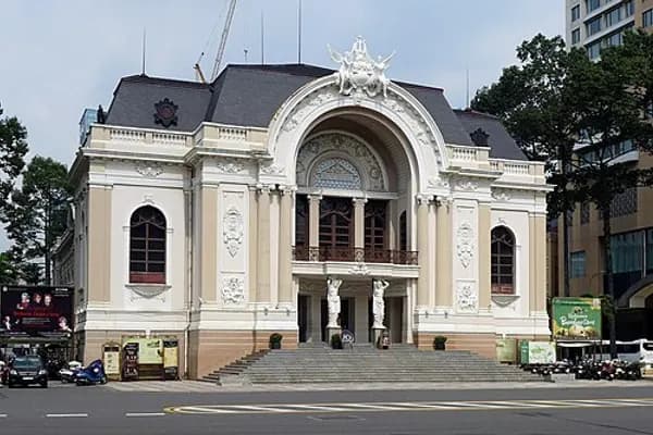
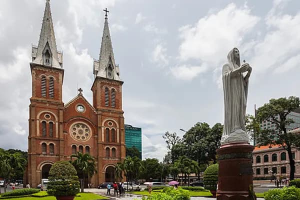
Ceded to France by the 1862 Treaty of Saigon, the city was planned by the French to transform into a town for colonization. During the 19th and 20th centuries, construction of French-style buildings began, including a botanical garden, the Norodom Palace, Hotel Continental, Notre-Dame Cathedral, and Bến Thành Market, among others. In April 1865, Gia Định Báo was established in Saigon, becoming the first newspaper published in Vietnam. During the French colonial era, Saigon became known as "Pearl of the Orient" (Hòn ngọc Viễn Đông), or "Paris of the Extreme Orient".
On 27 April 1931, a new région called Saigon–Cholon consisting of Saigon and Cholon was formed; the name Cholon was dropped after South Vietnam gained independence from France in 1955. From about 256,000 in 1930, Saigon's population rose to 1.2 million in 1950.
Gallery of Saigon during the French colonial era
State of Vietnam, and Republic of Vietnam
On 14 June 1949, 10 days after France returned Cochinchina to Vietnam, former emperor Bảo Đại made Saigon the capital of the State of Vietnam within the French Union with himself as head of state. The state was proclaimed in July. In July 1954, the Geneva Agreement partitioned Vietnam along the 17th parallel (Bến Hải River), with the Việt Minh, under Ho Chi Minh, gaining complete control of the northern half of the country, while the southern half remained under the rule of the State of Vietnam.
The State officially became the Republic of Vietnam when Bảo Đại was deposed by his Prime Minister Ngô Đình Diệm in the 1955 referendum, with Saigon as its capital. On 22 October 1956, the city was given the official name, Đô Thành Sài Gòn ("Capital City Saigon"). After the decree of 27 March 1959 came into effect, Saigon was divided into eight districts and 41 wards.
In December 1966, two wards from the old An Khánh Commune of Gia Định, were formed into District 1, then seceded later to become District 9. In July 1969, District 10 and District 11 were founded, and by 1975, the city's area consisted of eleven districts, Gia Định, Củ Chi District (Hậu Nghĩa), and Phú Hòa District (Bình Dương).
Saigon served as the financial, industrial and transport centre of the Republic of Vietnam. In the 1950s, with the U.S. providing nearly $2 billion in aid to the Diệm regime, the country's economy grew more rapidly under the capitalist model; by 1960, over half of South Vietnam's factories were located in Saigon. Beginning in the 1960s, Saigon experienced economic downturn and higher inflation, as it was completely dependent on U.S. aid and imports from other countries. As a result of urbanisation, with the population reaching 3.3 million by 1970, the city was described by the USAID as being turned "into a huge slum". The city had "prostitutes, drug addicts, corrupt officials, beggars, orphans, and Americans with money", and according to Stanley Karnow, it was "a black-market city in the largest sense of the word".
On 28 April 1955, the Vietnamese National Army launched an attack against Bình Xuyên military force in the city. The battle lasted until May, killing an estimated 500 people and leaving about 20,000 homeless. Ngô Đình Diệm then later turned on other paramilitary groups in Saigon, including the Hòa Hảo Buddhist reform movement. On 11 June 1963, Buddhist monk Thích Quảng Đức self-immolated in the city, in protest of the Diệm regime. On 2 November of the same year, Diệm was assassinated in Saigon, in a successful coup by Dương Văn Minh.
During the 1968 Tet Offensive, communist forces launched a failed attempt to capture the city. Seven years later, on 30 April 1975, Saigon was captured, ending the Vietnam War, and the city came under the control of the Vietnamese People's Army.
Gallery of Saigon during the Republic of Vietnam era
Socialist Republic of Vietnam
In July 1976, upon the establishment of the unified Socialist Republic of Vietnam, the city of Saigon (including the Cholon area), the province of Gia Ðịnh and two suburban districts of two other nearby provinces were combined to create Ho Chi Minh City, in honour of the late Communist leader Ho Chi Minh. At the time, the city covered an area of 1,295.5 square kilometres (500.2sqmi) with eight districts and five rurals: Thủ Đức, Hóc Môn, Củ Chi, Bình Chánh, and Nhà Bè. Since 1978, administrative divisions in the city have been revised multiple times, including in 2020, when District 2, District 9, and Thủ Đức District were consolidated to form a municipal city. On 29 October 2002, 60 people died and 90 were injured in the International Trade Center building fire in Ho Chi Minh City.
Ho Chi Minh City, along with its surrounding provinces, is described as "the manufacturing hub" of Vietnam, and "an attractive business hub". In terms of cost, it was ranked the 178th-most expensive major city in the world according to the Mercer Cost Of Living 2024 survey of 226 cities. In terms of international connectedness, as of 2024, the city was classified as a "Beta+" city by the Globalization and World Cities Research Network.
Geography
The city is located in Southeast Vietnam. The average elevation is 5m (16ft) above sea level for the city centre and 16m (52ft) for the suburb areas. It borders the provinces of Tây Ninh and Đồng Nai to the north, Đồng Nai and Lâm Đồng to the east, Tây Ninh to the west, and Đồng Tháp and the South China Sea to the south with a coast 89km (55mi) long. The city covers an area of 6.772km (2.615sqmi) or 2% of the surface area of Vietnam, extending up to Minh Thạnh commune (20km or 12mi from the Memot in Cambodia) and down to Côn Đảo special administrative region. The municipality also extends far to the east to Bình Châu (110km (68mi) from the city center). Due to its location on the Mekong Delta, the city is fringed by tidal flats that have been modified for agriculture.
Flooding
During the rainy season, a combination of tide, rains, flow volume in the Saigon River and Đồng Nai River and land subsidence results in flooding in parts of the city. A once-in-100 year flood would cause 23% of the city to undergo flooding.
Climate
The city has a tropical climate, specifically tropical savanna (Aw), with an average humidity of 78–82%. The year is divided into two seasons. The rainy season, with an average rainfall of about 1,800mm (71in) annually (about 150 rainy days per year), usually lasts from May to November. The dry season lasts from December to April.
The average temperature is 28°C (82°F). The highest temperature recorded was 40.0°C (104°F) in April while the lowest temperature recorded was 13.8°C (57°F) in January. On average, the city experiences between 2,400 and 2,700 hours of sunshine per year.
Administration
The city is a municipality at the same level as Vietnam's provinces, and is divided into 113 wards, 54 communes, and 1 special administrative zone (as of 2025):
113 wards (2,023.6266km or 781.3266sqmi in area), which are designated as urban or suburban (phường):
An Đông
An Hội Đông
An Hội Tây
An Khánh
An Lạc
An Nhơn
An Phú
An Phú Đông
Bà Rịa
Bàn Cờ
Bảy Hiền
Bến Cát
Bến Thành
Bình Cơ
Bình Dương
Bình Đông
Bình Hòa
Bình Hưng Hòa
Bình Lợi Trung
Bình Phú
Bình Quới
Bình Tân
Bình Tây
Bình Thạnh
Bình Thới
Bình Tiên
Bình Trị Đông
Bình Trưng
Cát Lái
Cầu Kiệu
Cầu Ông Lãnh
Chánh Hiệp
Chánh Hưng
Chánh Phú Hòa
Chợ Lớn
Chợ Quán
Dĩ An
Diên Hồng
Đông Hòa
Đông Hưng Thuận
Đức Nhuận
Gia Định
Gò Vấp
Hạnh Thông
Hiệp Bình
Hòa Bình
Hòa Hưng
Hòa Lợi
Khánh Hội
Lái Thiêu
Linh Xuân
Long Bình
Long Hương
Long Nguyên
Long Phước
Long Trường
Minh Phụng
Nhiêu Lộc
Phú An
Phú Định
Phú Lâm
Phú Lợi
Phú Mỹ
Phú Nhuận
Phú Thạnh
Phú Thọ
Phú Thọ Hòa
Phú Thuận
Phước Long
Phước Thắng
Rạch Dừa
Encyclopedic content adapted from the Wikipedia article on Thao Dien, used under CC BY-SA 4.0.