About the neighborhood
Area of Western District, Hong Kong
Sai Ying Pun is an area in Sai Wan, on Hong Kong Island, in Hong Kong. It is administratively part of the Central and Western District.
Location
Sai Ying Pun is built on the steeply sloping lower slopes of Victoria Peak and also on the western reclamation. The areas of Shek Tong Tsui and Kennedy Town are located to the west, Sheung Wan and Tai Ping Shan are to the east, and the Mid-Levels is higher up the hill to the south. Victoria Harbour is to the north.
While the boundaries are not de jure drawn, they are nevertheless de facto defined by Whitty Street in the west and Tung Wah Hospital in the east. The HKU MTR station exit B1 straddles the boundary between Shek Tong Tsui and Sai Ying Pun. Good Luck Mansion and The Kadoorie Biological Sciences Building are in Shek Tong Tsui, while Saint Anthony's Church, Pao Siu Loong Building, and the Main Building are in Sai Ying Pun.
The eastern boundary is blurry. Lok Sin Tong Leung Kau Kui College is in Sai Ying Pun while Tung Wah Hospital is in Sheung Wan. The section of Queens Road West from Medal Court to Hollywood Road marks part of the boundary. Elsewhere, the location of the border is unknown. On a map, Sai Ying Pun can be distinguished from Sheung Wan because it is left of the street grid of the Tai Ping Shan neighborhood.
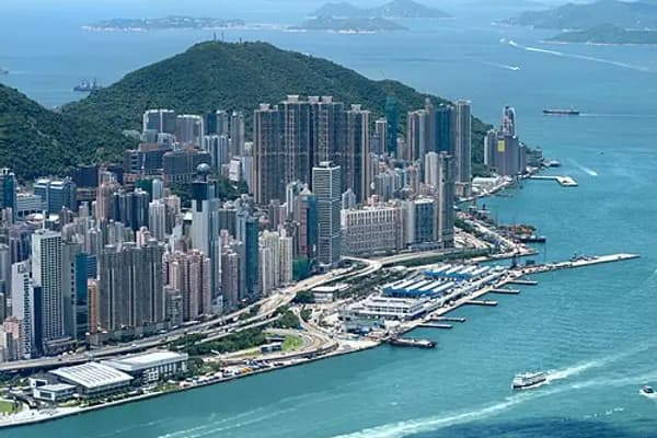
Sai Ying Pun, viewed from Hatton Road, Lung Fu Shan Country Park. West Kowloon (across Victoria Harbour), Sheung Wan and Central can also be seen. The two slopes on the both sides belongs to Lung Fu Shan and Victoria Peak respectively. Geology
Sai Ying Pun is built on top of Hong Kong granite. The granite was formed in the Upper Jurassic Period and is from the last phase of intrusions in the Hong Kong area. The granite is found over most of the north and centre of Hong Kong Island, and also Kowloon. The flat parts of Sai Ying Pun near the harbour are reclaimed land, built from landfill.
History
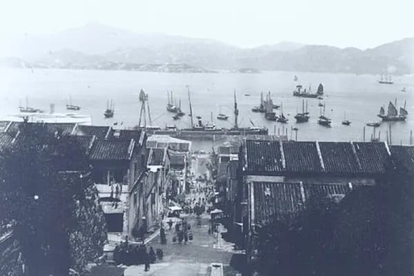
On January 26, 1841 (the 21st year of Emperor Daoguang's reign), the British army landed in Sai Ying Pun, which is now Possession Street (水坑口街), and Sai Ying Pun was not as prosperous as it is today. In May of that year, according to the population census published in the Hong Kong Gazette, there were approximately 7,450 people in Sai Ying Pun.
Sai Ying Pun, which developed in the 1850s, is a microcosm of Hong Kong history. Due to its location by the sea and steep mountains, the Hong Kong government chose Sai Ying Pun as the British military camp for the Bengal Volunteers from India, which had 800 Indian soldiers. The camp was located on the hillside of present-day Water Street.
In 1842, Canton Press (廣州周報) reported on the construction plan of Hong Kong: "About four miles from west to east along the northern bay, to the east is the peninsula where the Jardine Matheson Company's buildings are located, to the west is the military camp where the Bengal Volunteers are stationed, and a road connects the two east and west outposts." The Bengal Volunteers military camp referred to here is Sai Ying Pun (lit. the Western Military camp).
Queen's Road was the first road built in the area. It meandered around the camp structures and extended along the north coast of Hong Kong Island.
Sai Ying Pun was settled as Chinese immigrants moved into Hong Kong and built to the west of Tai Ping Shan. Europeans were assigned areas above High Street where Chinese were excluded from living.
In the early 1880s, sewerage was installed into the area, with the main flow coming down Centre Street. Streets were also macadamised or concreted at this time.
Around 1882, Battery Road was renamed Bonham Road.
From 1884 to 1887, many brothels were declared by the Government to be unlicensed and closed down. These were mainly in First, Second and Third Street, but also in Sheung Fung Lane, Ui On Lane and Centre Street.
In 1894, an epidemic of bubonic plague struck and afflicted Sai Ying Pun residents. It was not initially as bad as in neighbouring Tai Ping Shan, which was abandoned and demolished to improve hygiene. However, Sheung Fung Lane residents were almost wiped out. Government reports called this area the number IX health district and went into great detail about the buildings where the disease occurred. In 1896, there were 115 cases, in 1898, 153 cases, in 1899, 263 cases, in 1900 98 cases, in 1904 there were 149 cases with 144 dying, and 55 cases in 1905. The great majority of infections in this district resulted in death.
In 1902, number 10 and 12 Second Street partially collapsed killing four people and injuring six. An additional storey had been added to number 10 at the beginning of 1901. It fell on number 12 and caused it to collapse as well. The extension had been designed by architects Denison and Ram. Also in 1902, a cookhouse at 56 First Street collapsed, one person was killed.
In 1899, there were 1017 houses and a population estimate of 24,800. Most houses in Des Voeux Road and First Street were three stories, and in Second and Third Street they were two stories. In 1904 population was 24,900 and average occupancy per floor of each house was 8.9. In 1905, the population was 25083.
In 1903, most houses were made from soft blue bricks, they had basements, and retaining walls at the front and back due to the steep slope.
In the early 1900s, there was a Berlin Foundling House in High Street, a Sailors Home, and a Lunatic Asylum.
Main streets
Bonham Road
Centre Street
Connaught Road West
Des Voeux Road West
Eastern Street
First Street
High Street
Pok Fu Lam Road
Queen's Road West
Second Street
Third Street
Western Street
Whitty Street
Public facilities
Western District Community Centre (built 1922 as Tsan Yuk Hospital)
King George V Memorial Park, Hong Kong
Prince Philip Dental Hospital
Sun Yat Sen Memorial Park
Sai Ying Pun Community Complex
Sai Ying Pun Market
Education
Primary schools Bonham Road Government Primary School
Li Sing Primary School (李陞小學|zh)
Kennedy Town is in Primary One Admission (POA) School Net 11. Within the school net are multiple aided schools (operated independently but funded with government money) and Bonham Road and Li Sing government primary schools.
Li Sing Primary originated from the attached primary school of Northcote College of Education. Li Sing Primary is named after Li Sing, one of the co-founders of Tung Wah Group of Hospitals, and the father of Li Po-chun (李寶椿), who decided to fund the school because it carried his father's name. Li Po-chun gave $250,000 Hong Kong dollars towards the school's construction. Leigh & Orange built the school, which opened in February 1955. The Governor of Hong Kong formally opening the facility. Originally the school had 12 schools and special vocational facilities. It became a site for adult education in the evenings, catering to adults with no secondary education diplomas, on 18 October 1955. This was the first such adult education centre in Hong Kong. It is on the Sai Ying Pun Heritage Trail (西營盤歷史文化徑).
Secondary schools King's College
Lok Sin Tong Leung Kau Kui College
St. Louis School, Hong Kong
St. Paul's College, Hong Kong
St. Stephen's Church College
St. Stephen's Girls' College
University University of Hong Kong
Historical buildings
Source:
Grade 1
Façade of Old Mental Hospital (Sai Ying Pun Community Complex)
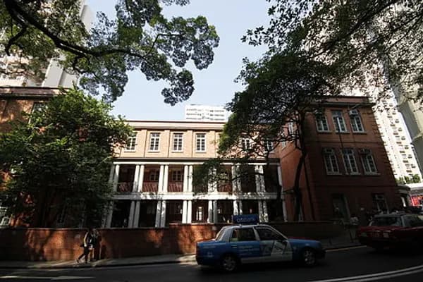
Old Tsan Yuk Maternity Hospital – Main Building
Tsung Tsin Mission of Hong Kong Kau Yan Church
King's College
Grade 2
No. 207 Des Voeux Road West – a four-storey shop house
Old Lunatic Asylum Chinese Block – Main Building & Staff Quarters
Old Tsan Yuk Maternity Hospital – Annex Block
St. Louis School, Hong Kong – East Wing
Grade 3
Tsung Tsin Mission of Hong Kong Kau Yan Church
No. 19 Hing Hon Road
Old Upper Levels Police Station
Nos. 9 and 10 Yu Lok Lane
References
Geological Map of Hong Kong 1979
Hong Kong Government Reports Online from Hong Kong University
External links
Media related to Sai Ying Pun at Wikimedia Commons
Landmarks Landmarks in Central
Bank of America Tower
Bonham Road
British Consulate
Breezy Path
Central and Western Heritage Trail
Civic Square
First houses on the Peak
Gate Lodge
Grenville House
Harcourt Garden
Headquarters House
High West
Hong Kong Museum of Medical Sciences
Hong Kong Zoological and Botanical Gardens
Island Pacific Hotel
King George V Memorial Park
Lippo Centre
Lung Fu Shan Country Park
Mount Davis Chiu Yuen Cemetery
Mountain Lodge
Ohel Leah Synagogue
Old Tsan Yuk Maternity Hospital
The Peak Galleria Hong Kong Trams Station (former)
Pacific Place Phases I-II JW Marriott Hotel Hong Kong
Island Shangri-La
Peak Tower
Queensway
Sai Ying Pun Community Complex
SoHo
Shun Tak Centre
South Korean Consulate
Smithfield
Tamar Park
Tim Mei Avenue
Tsan Yuk Hospital
Victoria Peak Garden
TransportHistory Peak District Reservation Ordinance 1904
This list is incomplete. Central has its own template due to the number of sites in that area. Sites specifically associated with University of Hong Kong are listed at the relevant template. Old KowloonNew KowloonNew TerritoriesOfficial place names are summarized from "Geoinfo Map" of Government of Hong Kong Special Administrative Region, "Hong Kong Guide" of Lands Department, "Hong Kong Guide Book" of Universal Publications Ltd. and "Areas and Districts" of Rating and Valuation Department. M:Narrow meaning of urban areas KL: Kowloon Peninsula at the south of Boundary Street NKL: Former New Territories area at the north of Boundary Street and at the south of Lion Rock 1: Common definition (1) 2: Common definition (2) 3: Common definition (3) 4: Areas not adopting small house concessionary right of indigenous inhabitants
5: Jurisdiction area of former Urban Council 6: Definition of "Metropolitan Area" of Planning Department 7: Jurisdiction area of Urban Renewal Authority 8: Unique operating area of urban taxis 9: "Urban" (9a) and "Extended Urban" (9b) areas defined by Hong Kong Housing Authority 10: Definition of Urban rates 11: Hospital cluster belongs to Hong Kong or Kowloon 12: Police region belongs to Hong Kong or Kowloon 13: Regions having 999-year land lease 14: Geographical Constituency in Hong Kong Legislative Council belongs to Hong Kong or Kowloon 15: Regional Education Office belongs to Hong Kong or Kowloon 16: Primary One Admission School Net belongs to Hong Kong or Kowloon KowloonNew TerritoriesSource: "Hong Kong Coastline map". "The history, current situation and future plans of Hong Kong's land reclamation" (in Chinese).
Encyclopedic content adapted from the Wikipedia article on Sai Ying Pun, used under CC BY-SA 4.0.