About the neighborhood
Central neighborhood in Mexico City
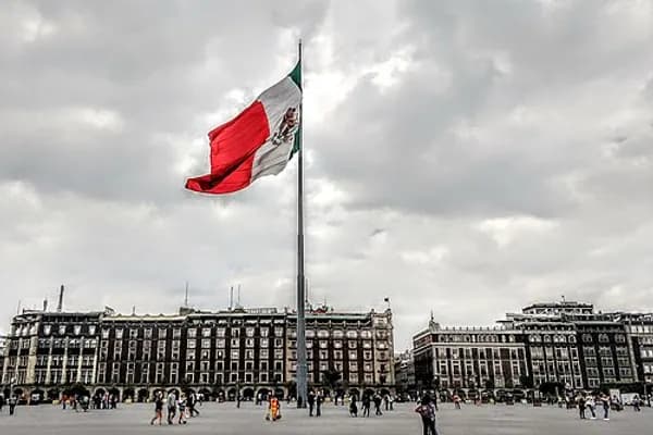
The historic center of Mexico City (Spanish: Centro Histórico de la Ciudad de México), also known as the Centro or Centro Histórico, is the central neighborhood in Mexico City, Mexico, focused on the Zócalo (or main plaza) and extending in all directions for a number of blocks, with its farthest extent being west to the Alameda Central. The Zocalo is the largest plaza in Latin America. It can hold up to nearly 100,000 people.
This section of the capital lies in the municipal borough of Cuauhtémoc, has just over nine km and occupies 668 blocks. It contains 9,000 buildings, 1,550 of which have been declared of historical importance. Most of these historic buildings were constructed between the 16th and 20th centuries. It is divided into two zones for preservation purposes. Zone A encompasses the pre-Hispanic city and its expansion from the Viceroy period until Independence. Zone B covers the areas all other constructions to the end of the 19th century that are considered indispensable to the preservation of the area's architectural and cultural heritage.
This is where the Spaniards began to build what is now modern Mexico City in the 16th century on the ruins of the conquered Tenochtitlan, capital of the Aztec Empire. As the centre of the Aztec Empire and the seat of power for the Spanish colony of New Spain, the Centro Historico contains most of the city's historic sites from both eras as well as a large number of museums. This has made it a World Heritage Site.
History
What is now the historic downtown of Mexico City roughly correlates with the ancient Aztec city of Tenochtitlan, which was founded around 1325. During the prehispanic era, the city developed in a planned fashion, with streets and canals aligned with the cardinal directions, leading to orderly square blocks. The island that the city was founded on was divided into four calpullis or neighborhoods that were divided by the main north-south roads leading to Tepeyac and Iztapalapa respectively and the west-east road that lead to Tacuba and to a dike into the lake, respectively. The calpullis were named Cuepopan, Atzacualco, Moyotla and Zoquipan, which had subdivisions and a "tecpan" or district council each. The intersection of these roads was the center of the city and of the Aztec world. Here were the Templo Mayor, the palaces of the tlatoani or emperors, palaces of nobles such as the "House of the Demons" and the "House of the Flowers". Also located here were the two most renowned Aztec schools: the Telpuchcalli for secular studies and the Calmecac for priestly training. When the Spaniards arrived, the city had aqueducts built by Moctezuma Ilhuicamina and Ahuizotl as well as a large dike constructed to the east of the city.
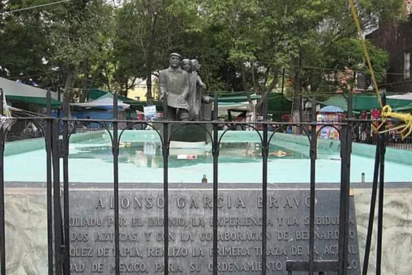
After the Spanish conquest, this design remained largely intact, mostly due to the efforts of Alonso Garcia Bravo, who supervised much of the rebuilding of the city. This reconstruction conserved many of the main thoroughfares such as Tenayuca, renamed Vallejo; Tlacopan, renamed México Tacuba, and Tepeyac, now called the Calzada de los Misterios. They also kept major divisions of the city adding Christian prefixes to the names such as San Juan Moyotla, Santa María Tlaquechiuacan, San Sebastián Atzacualco and San Pedro Teopan. In fact, most of the centro historicos is built with the rubble of the destroyed Aztec city.
A number of people during this time, all Spaniards, accumulated vast wealth mostly through mining and commerce in the 17th and 18th centuries. This wealth is reflected in the various mansions scattered in the centro such as the Palace of Iturbide and Casa de Azulejos (House of Tiles). This house was built in the 16th century in Arab style but its namesake tiles were added in 1747 when the Count of the Valley of Orizaba ordered the Talavera tiles from Puebla.
In the early part of the 20th century, as a result of the Latin American posture of then-Minister of Public Education José Vasconcelos, many of the streets to the north and west of the Zocalo were renamed after Latin American countries.
The Zócalo and surrounding sites
Historically, the Zócalo, or main plaza, has been a venue for fine and popular cultural events. Some example of events held here recently are Spencer Tunick's photo shoot, the Ashes and Snow Nomadic museum and a skateboarding/BMX event that drew 50,000 young people on 24 August 2008. The Festival de México is an annual event with programs dedicated to art (popular and high) and academia. In 2008, was the 24th Festival with 254 performances and shows from over 20 countries in 65 plazas and other locations in this section of the city.
It is central to national level protests such as those staged by Lopez Obrador after the 2006 Presidential Elections and the nationwide protest against crime held on August 30, 2008.
Just off the Zócalo are the Palacio Nacional, the Cathedral Metropolitana, the Templo Mayor with its adjoining museum, and Nacional Monte de Piedad building. The Palacio Nacional borders the entire east side of the Zocalo and contains the offices of the President of Mexico, the Federal Treasury, the National Archives as well as murals depicting pre-Hispanic life and a large mural filling the central stairway depicting the entire history of the Mexican nation from the Conquest on. This palace was built on the ruins of Moctezuma II's palace beginning in 1521, using the same tezontle stone used to build the Aztec palace. It was originally in the Hernán Cortés family until the king of Spain bought it to house the viceroys of New Spain and remained so (despite being destroyed and rebuilt again in 1692) until Mexican independence. Facing the Zócalo above a central balcony is the Campana (Bell) of Dolores, which is rung by the president each 15th of Sept to celebrate Independence.
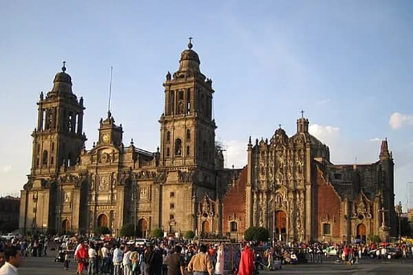
The Metropolitan Cathedral, dedicated to the Assumption of the Most Blessed Virgin Mary, occupies the north end of the Zócalo. The site originally was part of the Aztec Sacred Precinct (called the Teocalli) and contained the main tzompantli, or rack for the skulls of sacrifice victims. The first church was erected between 1524 or 1526 and 1532 and was elevated to the rank of cathedral on 2 September 1530 by Pope Clement VII. The foundations for a new cathedral were begun in 1562 and the foundation stone was laid in 1573 in the time of Archbishop Pedro Moya de Contreras and of the 4th Viceroy. Although the works had not been concluded, the cathedral received its first dedication on 2 February 1656. The completion in 1813 of the neo-classical additions designed by Manuel Tolsá was celebrated on 15 August 2013 by Cardinal Carrera who opened and entered through the Holy Door in the center of the façade prior to celebrating Pontifical High Mass in the cathedral.
Between 1989 and 2000 extensive engineering works were conducted to arrest and rectify damage and distortions caused to the structure by the uneven rate and extent of the sinking of the building provoked by the continuous settlement of the ground on which it stands. This began with the drainage of the lake of the Valley of Mexico initiated in 1607 and has continued with the reduction of the water-table caused by the pumping of water for use by Mexico City's rapidly expanding population. The last of the temporary props which had disfigured the interior of the building during the engineering works were removed on 28 November 2000.
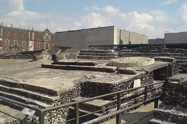
The Templo Mayor archeological site and museum, is the center of the ancient teocalli, located now just northeast of the Zócalo. It was demolished by Hernán Cortés in the 1520s and its location forgotten. The exact site was determined in the beginning of the 20th century, but the decision to excavate was not made until 1978, when electrical workers chanced upon an eight-ton stone disk depicting the Aztec goddess Coyolxauhqui. Excavation unearthed a pyramid built in multiple layers. This is the spot where, according to legend, the Aztecs saw their sign to settle from their wanderings, an eagle perched on a nopal cactus with a snake in its beak, which is still the symbol of Mexico today.
The Nacional Monte de Piedad building is the national pawn shop, founded in 1775 and one of the largest second-hand shops in the world. On this site were houses that belonged to the last Aztec ruler, Moctezuma II, which Hernán Cortés took for his own after the Conquest. These houses originally stretched from modern-day Isabel la Catolica, Madero, Tacuba and Monte de Piedad streets, prompting one chronicler, Cervantes de Salazar to comment that the residence was not a palace but rather another city.
Notable sites north of the Zócalo
Santo Domingo refers to the Church of Santo Domingo and the adjoining plaza. Both are located three blocks north of the Mexico City Metropolitan Cathedral following Republica de Brasil Street with Belisario Dominguez Street separating the two. Officially known as the Señor de la Expiación Chapel, the church is located on the north side of Belisario Dominguez and faces the plaza. It is all that is left from the first convent to be established in New Spain. To the south of the church is Plaza San Domingo. It is flanked to the west by the Portal de Evangelistas, which is a Tuscan colonnade with round arches. Scribes with typewriters and antique printing machines work in this Portal. Scribes offer their services to illiterate clients, often offering services similar to that of lawyers, counselors, and financial consultants. A statue of Josefa Ortiz de Domínguez, a heroine of the Mexican War of Independence stands in a fountain in the middle of the plaza.
The San Ildefonso College currently is a museum and cultural center considered to be the birthplace of the Mexican muralism movement. San Ildefonso began as a prestigious Jesuit boarding school, and after the Reform War, it gained educational prestige again as National Preparatory School. This school and the building closed completely in 1978, then reopened as a museum and cultural center in 1994. The museum has permanent and temporary art and archeological exhibitions in addition to the many murals painted on its walls by José Clemente Orozco, Diego Rivera and others. The complex is located between San Ildefonso Street and Justo Sierra Street in the historic center of Mexico City.
Secretaría de Educación Pública at Calle Argentina
Centro Cultural de España (Cultural Center of Spain), located on Republica de Guatemala street just north of the Mexico City Cathedral
Museum Archive of Photography, located at the corner of Republica de Guatemala and Republica de Argentina Street
Lirico Theatre, located on Republica de Cuba street
Antigua Escuela de Economía (Old School of Economics), located on Republica de Cuba Street
Colegio Nacional, located on The Colegio Nacional Building, located on Luis Gonzalez Obregon Street
Old Customs building, on Republica de Brasil just off the Plaza Santo Domingo
Palace of the Inquisition (Museum of Mexican Medicine) located on Republica de Brasil
Notable sites south of the Zócalo
The Supreme Court of Justice of the Nation is located just off the Zócalo, on the corners of Pino Suárez and Carranza Streets. It was built between 1935 and 1941 by Antonio Muñoz Garcia. Prior to the Conquest, this site was reserved for the ritual known as "Dance of the Flyers" which is still practiced today in Papantla. Its ownership was in dispute during much of the colonial period, eventually becoming the site of a very large market known as El Volador. The interior of the building contains four panels painted in 1941 by José Clemente Orozco, two of which are named "The Social Labor Movement" and "National Wealth." There is also one mural done by American artist George Biddle entitled "War and Peace" at the entrance to the library.
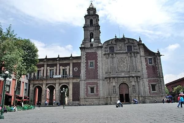
Temple of Saint Augustine Located on Avenida Republica de El Salvador
The original El Palacio de Hierro store located on Carranza and 20 de noviembre streets
The original Liverpool department store on Carranza and 20 de noviembre streets
Saint Augustine House Located on Republica de Uruguay and 5 de Febrero streets
The Chapel of the Most Holy Conception of Tlaxcoaque, one of the oldest churches in Mexico City, on Fray Servando de Mier
Church of San Bernardo off the Zocalo
Notable sites west of the Zocalo
The Palace of Iturbide - this large palatial home on Madero Street #17 was built by the Count of San Mateo Valparaíso in the 18th century as a wedding gift for his daughter. It gained the name "Palace of Iturbide" because Agustín de Iturbide lived and accepted the crown as Mexico's first emperor there after independence from Spain. Today, the restored building houses the Fomento Cultural Banamex and has been renamed the Palacio de Cultura Banamex.
The Torre Latinoamericana - This is one of the best-known skyscrapers in Latin America. It was begun in 1948 and completed in 1956 and is 182 meters tall, antennae included. It is located on the corner of Eje Central and Juarez Streets. It was the tallest tower in Mexico prior to the construction of Torre Pemex. The building has survived two major earthquakes since it was built, one in 1957 and the other in 1985.
The Museo Nacional de Arte (MUNAL) is the Mexican National Art Museum, housed in a neoclassical building at No. 8 Tacuba, Colonia Centro. It houses a collection representing the history of Mexican art from the late pre-Hispanic era to the early 20th century. It is recognizable by Manuel Tolsá's large equestrian statue of Charles IV of Spain who was the monarch just before Mexico gained its Independence. It was originally in the Zocalo but it was moved to several locations, not out of deference to the king but rather to conserve a piece of art, according to the plaque at the base. It arrived to its final location in 1979.
The Palacio de Correos de Mexico (Postal Palace of Mexico City) also known as the "Correo Mayor" (Main Post Office) is located on the Eje Central (Lázaro Cárdenas) near the Palacio de Bellas Artes. It is an early 20th-century building built in the style of an Italian Renaissance palace. It was designed by Italian Adamo Boari, who also designed part of the Palacio de Bellas Artes across the street.
Casa de los Azulejos a former mansion completely covered in blue and white Puebla tile between Avenida Madero and Avenida Cinco de Mayo
Colegio de Minería (College of Mining) on Tacuba Street
Mexican Army Museum originally Bethlemites Hospital, located at Tacuba and Mata
Garden of the Triple Alliance on corner of Tacuba and Mata
Cámara de Senadores on Xicoténcatl Street
Museo de Estanquillo (cartoons and magazines) on corner of Isabel la Catolica and Madero
Temple of San Felipe Neri "La Profesa" with collection of artwork from the 17th to 20th centuries, and guided tours on Saturdays from 1200 to 1400 hrs
Interactive Museum of Economics on Tacuba Street
Santa Clara church - Library of Congress on corner of Tacuba and Mata
Encyclopedic content adapted from the Wikipedia article on Centro Histórico, used under CC BY-SA 4.0.