About the neighborhood
Central area of Christchurch, New Zealand
Christchurch Central City or Christchurch City Centre is the geographical centre and the heart of Christchurch, New Zealand. It is defined as the area within the Four Avenues (Bealey Avenue, Fitzgerald Avenue, Moorhouse Avenue and Deans Avenue) and thus includes the densely built up central city, some less dense surrounding areas of residential, educational and industrial usage, and green space including Hagley Park, the Christchurch Botanic Gardens and the Barbadoes Street Cemetery.
It suffered heavy damage in the September 2010 Canterbury earthquake and was devastated five months later, in the February 2011 Christchurch earthquake. Following this second earthquake, the Central City Red Zone was set up and, with a gradually shrinking area, remained inaccessible except to authorised contractors until June 2013. However, proposals to relocate the city centre elsewhere, to avoid future damage, were considered both uneconomical (as much of the infrastructure was still mainly intact) and unnecessary, as the rebuilt city centre would be to modern building standards so as to be able to withstand similar quakes and the associated liquefaction in the future.
Geography
Christchurch Central City is built on land that has been formed by gravel and other sediment within the last 7,000 years or thereabouts.
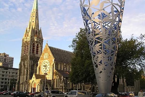
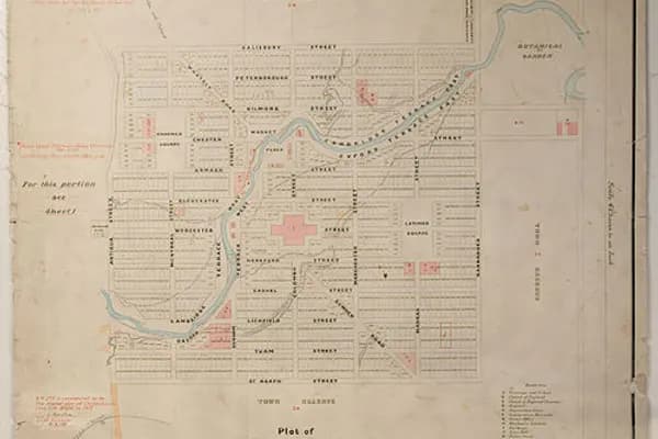
At the centre of the city is Cathedral Square, surrounding the Anglican cathedral, Christ Church. The area around this square and within the four avenues of Christchurch is considered the central business district of the city.
The city centre is laid out in a grid pattern, interrupted only by the curvilinear alignment of the Avon River / Ōtākaro, and the two diagonals High Street and Victoria Street. Christchurch has four pairs of one-way streets. The grid pattern within the outermost one-way streets is very regular, as this is the area that was laid out in the original survey. The surrounding area, i.e. the belt between the outer one-way streets and the avenues, was developed later in a progressive fashion and does not have the regularity of the core area.
Like most of the city, the centre is relatively flat. Before the earthquakes, Christchurch was home to many high rise buildings, but many of these were demolished following the 2011 Christchurch earthquake. Tall buildings left include Pacific Tower and Forsyth Barr Building, which dominate the skyline and can be seen throughout the city.
History
Prehistory
Māori were the first occupants on the area covering modern-day Christchurch. There were permanent or semi-permanent settlements on the margins of the estuary (notably at the mouth of the Otakaro/Avon) and on the first areas of higher, drier ground up the Avon and Heathcote Rivers. There were two kāinga on the site of Central Christchurch: Puāri near Victoria Square, an important food-gathering place for Māori and Tautahi Pā, located further east of the Puāri kāinga.
European settlement
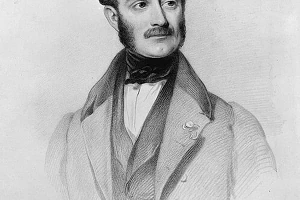
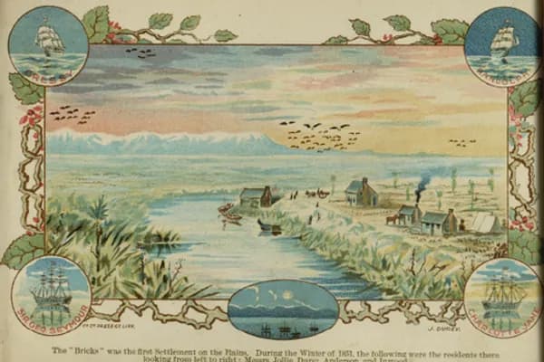
The European settlement of Christchurch was undertaken by the Canterbury Association, which was founded in London in 1848. That year, the Canterbury Association sent out Captain Joseph Thomas, accompanied by surveyors, to select and prepare a site for settlement. Thomas originally placed the principal town of the proposed settlement at the head of Lyttelton Harbour / Whakaraupō, but when he realised there was insufficient flat land there to meet the Canterbury Association's requirements, he relocated Christchurch to where he had previously placed a town called 'Stratford' at a point on the Avon where those coming up the river first encountered slightly higher, drier ground. Back then, the Avon River / Ōtākaro was navigable as far as 'The Bricks' just upstream of the Barbadoes Street bridge. The site is these days marked by a riverbank cairn. The site got its name when the Deans Brothers in the 1840s had shipped bricks for their Riccarton homestead, located further up the river, which they unloaded in this location.
Survey layout
Christchurch is one of a group of only four cities in the world that have been carefully planned following the same layout of a central city square, four complementing city squares surrounding it and a parklands area that embrace the city centre. The first city built with this pattern was Philadelphia, later came Savannah and Adelaide. The fourth city using this pattern was Christchurch. As such Christchurch holds an important legacy and a strong platform for future development.
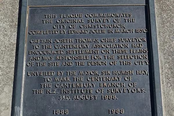
Thomas' plan for Christchurch (laid out by the surveyor Edward Jollie by March 1850) was the 'standard' rectangular grid of colonial settlement (adopted for ease of survey and to facilitate land sales). Thomas did not allow Jollie to include crescents to provide variety, but the Avon River / Ōtākaro ran eccentrically across the site. Two diagonal streets (High Street/Ferry Road leading to Ferrymead, Heathcote and Sumner and Victoria Street/Papanui Road leading to the Papanui Bush) also broke the regularity of the grid. At the very centre of the city was a 'Square' (which is actually cross-shaped) intended as a grand centre for the city and the site of the proposed cathedral and grammar school. East and north-west of the Square were two more 'squares' (Latimer and Cranmer Squares, which are actually rectangles) which were placed more or less regularly in relation to the diagonal line of Ōtākaro running in a north-easterly direction across the city to the west and north of the central square.
The grid was laid out originally between Salisbury Street to the north and St Asaph Street to the south and between Barbadoes Street to the east and Rolleston Avenue/Park Terrace to the west. Between Salisbury, Barbadoes and St Asaph Streets and (respectively) the North, East and South Town Belts (these days called Bealey, Fitzgerald and Moorhouse Avenues) were 'town reserves', i.e. land with-held from immediate sale, which was sold off by the Provincial Government later in the 1850s to overcome cash flow problems. The streets of the original grid were mostly projected out to the Town Belts, but the street system is less systematic in the former 'town reserves'. The names chosen for the streets of the inner city almost all commemorate the English colonial origins of the settlement. The names chosen later for the town belts commemorate important personalities of early Christchurch. Jollie explains in his diary how the streets got their names:
The names of the streets of the three towns I surveyed were taken from Bishoprics and the way it was done was this; as soon as I completed the map I took it to Thomas who putting on his gold spectacles and opening his would read out a Bishop's name to hear if it sounded well. If I agreed with him that it did, I put the name to one of the streets requiring baptism. Lyttelton being the first born town got the best names for its streets, Sumner being next had the next best and Christchurch being the youngest had to be content with chiefly Irish and Colonial bishoprics as names for its streets. This accounts for, what to anyone not knowing the circumstances, appears strange, viz: that many of the best English Bishoprics are not represented while Irish and Colonial ones are. Sumner in fact died too late for the names there used to be again employed in Christchurch.
The original plan from 1850 shows the north-west corner of the 'town reserves' (surrounded by the Avon River / Ōtākaro, Fitzgerald and Bealey Avenues and Barbadoes Street, with an additional small rectangular area to the west of Barbadoes Street) as the cemetery for the settlement. Individual town sections were shown on the survey plan, the Black Map, and numbered by the surveyors in a logical order, in contrast to the rural sections surrounding Christchurch, which were numbered at the time of and in the order of their purchase.
The following streets were those laid out in the 1850 survey (listed east to west, then north to south, then diagonals). Where a street name is one of the original names as devised by surveyors Joseph Thomas and Edward Jollie, this is marked as such.
Streets running north–south
Deans Avenue – the original name for this street was West Belt. In 1905, it got renamed to Rolleston Avenue, but was called West Belt again in 1906. Deans Avenue is named after the Deans family, who farmed at Riccarton from 1843 onwards.
Harper Avenue – this street was formerly called Park Road and North Park Road. It was so named because it runs alongside Hagley Park. It was renamed Harper Avenue by city council resolution on 18 May 1931 in honour of the retiring chairman of the Christchurch Domains Board George Harper (1843–1937).
Rolleston Avenue – this street formerly belonged to Antigua Street. The section between Cambridge Terrace and Armagh Street was renamed in honour of William Rolleston on 11 January 1903, about one month before his death. This street was chosen because of his association with Canterbury College (now the Christchurch Arts Centre, which adjoined Antigua Street and also because it was proposed to erect his statue there.
Park Terrace – this street appears as Mill Road on an 1862 map. Park Terrace, named because it runs adjacent to Hagley Park, first appears in street directories in 1880.
Cranmer Square (original street name) – Cranmer Square is adjacent to the square of the same name and is named after the martyred Oxford bishop Thomas Cranmer.
Montreal Street (original street name) – this street is named after the Anglican Diocese of Montreal in Canada. The surveyors ran out of English bishoprics to use as street names so moved on to other colonies.
Durham Street (original street name) – the street was named after the Diocese of Durham. On 21 October 1985 the council resolved for the two separate sections of Durham Street (between Gloucester Street and Cashel Street, which is part of Cambridge Terrace) to be renamed Durham Street North and South.
Colombo Street (original street name) – this street is named after the colonial Anglican bishopric Colombo in what at the time was known as Ceylon.
Manchester Street (original street name) – this street is named after William Montagu, 7th Duke of Manchester, who was a member of the Canterbury association in 1848.
Latimer Square (original street name) – the street adjacent to Latimer Square is named after the martyred Oxford bishop Hugh Latimer.
Madras Street (original street name) – this street is named after the colonial Anglican bishopric of Madras (now known as Chennai) in India.
Barbadoes Street (original street name) – this street is named after the Anglican colonial Diocese of Barbados in the West Indies, now known as the Caribbean. The Christchurch spelling of Barbados with an additional 'e' is as per the original survey plan drawn by Edward Jollie.
Fitzgerald Avenue – the original names for this street were East Town Belt and East Belt. The street was renamed by council on 11 January 1904 in honour of James FitzGerald.
Streets running east–west
Bealey Avenue – the original name for this street was North Belt and North Town Belt. On 11 January 1904, it got renamed in honour of Canterbury's third Superintendent Samuel Bealey, who owned land in this area.
Salisbury Street (original street name) – the street is named after the English Diocese of Salisbury.
Peterborough Street (original street name) – the street is named after the Anglican Diocese of Peterborough.
Kilmore Street (original street name) – the street is named after the Irish Diocese of Kilmore.
Chester Street (original street name) – the street is named after the English Anglican Diocese of Chester. It appears in 1883 street directories as Chester Street between East Town Belt and Colombo Street, and Chester Street West between Cambridge Terrace and Park Terrace. Chester Street West was renamed Cranmer Terrace for a short time in the 1950s because of the gap in Chester Street between Colombo Street and Cambridge Terrace. It reverted to its earlier name when the residents found that there was confusion with Cranmer Square.
Armagh Street (original street name) – the street is named after the Diocese of Armagh.
Gloucester Street (original street name) – the street is named after the Diocese of Gloucester.
Worcester Street (original street name) – the street is named after the Anglican Diocese of Worcester.
Hereford Street (original street name) – the street is named after the Diocese of Hereford.
Cashel Street (original street name) – the street is named after the bishopric of Cashel.
Lichfield Street (original street name) – the street is named after the Diocese of Lichfield.
Tuam Street (original street name) – the street is named after the Irish Diocese of Tuam.
St Asaph Street (original street name) – the street is named after the Diocese of St Asaph in Wales.
Moorhouse Avenue – the original name for this street was South Belt and South Town Belt. On 11 January 1904, it got renamed in honour of Canterbury's second superintendent William Sefton Moorhouse, who had championed the development of Christchurch-Lyttelton railway and the Lyttelton rail tunnel. It was thus thought appropriate that the avenue adjacent to the railway be named after him.
Other streets
Cambridge Terrace (original street name) – the street is named after the University of Cambridge in England. Waterloo Terrace was the name on the first plan of the road along the Avon River / Ōtākaro from Market Place (now Victoria Square) to past the Foresters' Hall, i.e. from near the Oxford-on-Avon and the Plunket Society round to near the Centennial Leisure Centre. Avonside Road was the section just south of the Barbadoes Street Cemetery, adjacent to the river bank and the river, across the river from the Avon Loop, east of Barbadoes Street and round to Fitzgerald Avenue.
Oxford Terrace (original street name) – the street is named after the University of Oxford. John Robert Godley, considered to be the founder of Christchurch, had studied at Christ Church, one of the colleges of the University of Oxford.
Victoria Street – this street was originally named Whately Road after Richard Whately, who was a member of the Canterbury Association. It was renamed Victoria Street in 1877 after a petition signed by 61 residents was presented asking that the name be changed. The current street name commemorates Queen Victoria.
High Street – this street was originally named Sumner Road, as it connected to the village of Sumner. At the time, Sumner was of great importance to Christchurch, as a road over the Port Hills was to be built connecting Lyttelton with Sumner. The section north of St Asaph Street was renamed High Street.
Ferry Road – the central city-end of Ferry Road was originally called Sumner Road. The section south of St Asaph Street was renamed Lower High Street, and then Ferry Road.
Important Canterbury Association members
Encyclopedic content adapted from the Wikipedia article on Central City, used under CC BY-SA 4.0.